| Bull Shoals Fishing Guide - Bull Shoals Lake in AR & MO, USA - Point 12 Fishing Guide Service | ||||||||||
 |
||||||||||
| Alfred Denninger | Email alfred@denninger.com | AR 870-436-3974 - MO (cell) 417-712-4991 | ||||||||||
| ABOUT US PHOTO GALLERY RATES & WHAT TO BRING BOAT & EQUIPMENT TECHNIQUES USED TOURNAMENTS & AWARDS TESTIMONIALS SUNSETS ABOUT BULL SHOALS LAKE ONLINE FISHING TACKLE SHOP BOAT DOCKS, LIFTS & DOCK TENDING SERVICE CONTACT US & BOOK A DATE HOME TO POINT12.COM |
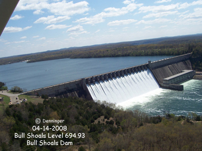
ABOUT BULL SHOALS LAKEBull Shoals Lake covers 45,000 acres with a 700+ mile shoreline at 654
feet above sea level, and grows to more than 70,000 acres with a 1,000 mile
shoreline at full pool of 695 feet. Bull Shoals Dam was built to impound the
White River and was one of the largest concrete dams in the United States, and
the 5th largest dam in the world at its inception. The work on the dam began in
1947, was completed in 1951 and dedicated by President Truman in 1952. WEATHER, LAKE LEVELS &
|
|||||||||
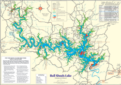 Click the photo for a printable detailed map of Bull Shoals Lake in PDF |
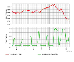 Click the graph for live Bull Shoals Lake Levels, Precipitation and Generation Graphs directly from the Army Corps of Engineers website |
 Click the COE Logo for the calculated daily forcast of Lake levels on Bull Shoals Lake in Arkansas & Missouri |
 Click the NOAA Logo to get the weather forcast right here on Point 12 of Bull Shoals Lake |
 Click the Accuweather logo for the 15-day forcast and from here you can even drill down to the hourly forcast right here on Point 12 of Bull Shoals Lake AR MO |
 Link to the National Weather Service Enhanced Radar Image Loop for Point 12 of Bull Shoals Lake |
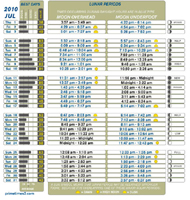 Click the graph for this month's Solunar Tables provided by Fintalk |
Copyright 2011 - All rights reserved by
BullShoalsFishingGuide.com a subsidiary of Point12.com
Alfred Denninger, HC 3 Box 3335 Theodosia, MO 65761, USA